

 Share
Share RSS
RSS Seller Articles
Buyer Articles
Commercial Property Request
Commercial Property Value
Property Management Request
Live News
Foreclosures
Torrance, California
| Torrance, California | |||
|---|---|---|---|
| City | |||
| City of Torrance | |||
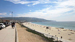 View of Torrance Beach with neighboring Palos Verdes in the background
 |
|||
|
|||
| Nickname(s): T Town | |||
| Motto: A Balanced City | |||
 Location of Torrance in the County of Los Angeles
 |
|||
| Coordinates: 33�50?5?N 118�20?29?W / 33.83472�N 118.34139�W / 33.83472; -118.34139Coordinates: 33�50?5?N 118�20?29?W / 33.83472�N 118.34139�W / 33.83472; -118.34139 | |||
| Country | |||
| State | |||
| County | |||
| Incorporated | May 12, 1921 | ||
| Government | |||
| o Type | Council-Manager | ||
| o City Council | Mayor Frank Scotto (R) Gene Barnett Tom Brewer Pat Furey Cliff Numark Susan Rhilinger Bill Sutherland | ||
| o City Treasurer | Dana Cortez | ||
| o City Clerk | Sue Herbers | ||
| Area | |||
| o Total | 20.553 sq mi (53.233 km2) | ||
| o Land | 20.478 sq mi (53.038 km2) | ||
| o Water | 0.075 sq mi (0.195 km2) 0.37% | ||
| Elevation | 89 ft (27 m) | ||
| Population (2012) | |||
| o Total | 147,027 | ||
| o Rank | 8th in Los Angeles County 36th in California 166th in the United States | ||
| o Density | 7,200/sq mi (2,800/km2) | ||
| Time zone | PST (UTC-8) | ||
| o Summer (DST) | PDT (UTC-7) | ||
| ZIP codes | 90501-90510 | ||
| Area code(s) | 310, 424 | ||
| FIPS code | 06-80000 | ||
| GNIS feature ID | 1652802 | ||
| Website | http://www.TorranceCA.gov | ||
 Flag
Flag Seal
Seal
History
Torrance was originally part of the Tongva Native American homeland for thousands of years. In 1784 the Spanish land grant for Rancho San Pedro, in the upper Las Californias Province of New Spain and encompassing present day Torrance, was issued to Juan Jose Dominguez by King Carlos III--the Spanish Empire. It was later divided in 1846 with Governor P�o Pico granting Rancho de los Palos Verdes to Jos� Loreto and Juan Capistrano Sepulveda, in the Alta California territory of independent Mexico.
In the early 1900s, real estate developer Jared Sidney Torrance and other investors saw the value of creating a mixed industrial-residential community south of Los Angeles. They purchased part of an old Spanish land grant and hired landscape architect Frederick Law Olmsted, Jr. to design a new planned community. The resulting town was founded in October 1912 and named after Torrance. The city of Torrance was formally incorporated in May 1921. The first residential avenue created in Torrance was Gramercy and the second avenue was Andreo. Many of the houses on these avenues turned 100 years of age in 2012. Both avenues are located in the area referred to as Old Town Torrance. This section of Torrance is under review to be classified as a historical district. Some of the early civic and residential buildings were designed by the renowned and innovative Southern California architect Irving Gill, in his distinctive combining of Mission Revival and early Modernist architecture.
Historically the El Nido neighborhood was home to many European immigrants, such as originally Dutch, German, Greek, Italian and Portuguese people; soon joined by Mexican-American and Hispanic and Latino immigrants; employed in the growing early 20th century agriculture, petroleum, and manufacturing industries, such as the fish canneries.[citation needed]
Rapid new growth in Torrance began after World War II as wartime industries transformed into Post-war Aerospace manufacturers and related technology industries. Large housing developments were built in the 1950s and 1960s to accommodate the new population. Torrance moved on after the closure of some aerospace development and oil refinery plants in the 1990s statewide recession.[citation needed]
Torrance survived the deindustrialization, regional economic slowdowns and national recessions in the 1970s to 2000s. Large-scale Asian immigration in the past couple of decades has transformed Torrance into a diverse and multicultural city.
According to Forbes, Torrance, along with Glendale, CA, San Francisco, CA, Los Angeles, CA, and Fullerton, CA were all named 'Cities With The Worst Drivers 2012'.
Overview
Torrance is a city incorporated in 1921 and located in the South Bay (southwestern) region of Los Angeles County, California, United States. Torrance has 1.5 miles (2.4 km) of beaches on the Pacific Ocean, which are quieter and less well known by tourists than others on the Santa Monica Bay, such as those of neighboring Redondo Beach and Manhattan Beach. Torrance enjoys a moderate year-round climate with warm temperatures, sea breezes, low humidity and an average rainfall of 12.55 inches per year.
The population of Torrance was 145,438 at the 2010 census. This residential and light high-tech industries city has 90,000 street trees and 30 city parks. Known for its low crime rates, the city consistently ranks among the safest cities in Los Angeles County. Torrance is the birthplace of the AYSO - American Youth Soccer Organization. In addition, the city of Torrance has the second highest percentage of Japanese in North America. (8.88%)
Geography
Torrance is located at 33�50?5?N 118�20?29?W / 33.83472�N 118.34139�W / 33.83472; -118.34139 (33.834815, -118.341330). . The United States Census Bureau boundaries show the city has a total area of 20.5 square miles (53 km2), virtually all land.
Torrance is a coastal community in southwestern Los Angeles County, as seen on the map above, sharing the climate and geographical features common to the Greater Los Angeles area. Its boundaries are: Redondo Beach Boulevard and the cities of Lawndale and Gardena to the north; Western Avenue and the Harbor Gateway neighborhood of Los Angeles to the east; the Palos Verdes Hills with the cities of Lomita, Rolling Hills Estates and Palos Verdes Estates on the south; and the Pacific Ocean and city of Redondo Beach to the west.
Torrance Beach lies between Redondo Beach and Malaga Cove on Santa Monica Bay. The southernmost stretch of Torrance Beach, on a cove at the northern end of the Palos Verdes peninsula, is known to locals as "Rat Beach."
One of the country's few urban wetlands, the Madrona Marsh, is found in Torrance to explore. It is a nature preserve, on land once set for oil production and saved development, with restoration projects enhancing the vital habitat for birds, wildlife, and native plants. A Nature center provides activities, information, and classes for school children and visitors of all ages.
Residents of an unincorporated area to the east of Harbor Gateway abutting the city of Carson are allowed to use "Torrance" in their addresses by the United States Postal Service.
Demographics
Torrance is a coastal community in southwestern Los Angeles County, as seen on the map above, sharing the climate and geographical features common to the Greater Los Angeles area. Its boundaries are: Redondo Beach Boulevard and the cities of Lawndale and Gardena to the north; Western Avenue and the Harbor Gateway neighborhood of Los Angeles to the east; the Palos Verdes Hills with the cities of Lomita, Rolling Hills Estates and Palos Verdes Estates on the south; and the Pacific Ocean and city of Redondo Beach to the west.
Torrance Beach lies between Redondo Beach and Malaga Cove on Santa Monica Bay. The southernmost stretch of Torrance Beach, on a cove at the northern end of the Palos Verdes peninsula, is known to locals as "Rat Beach."
One of the country's few urban wetlands, the Madrona Marsh, is found in Torrance to explore. It is a nature preserve, on land once set for oil production and saved development, with restoration projects enhancing the vital habitat for birds, wildlife, and native plants. A Nature center provides activities, information, and classes for school children and visitors of all ages.
Residents of an unincorporated area to the east of Harbor Gateway abutting the city of Carson are allowed to use "Torrance" in their addresses by the United States Postal Service.